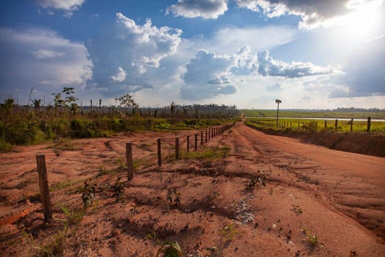

They were supposed to be a protective shield for the forest alongside a federal highway, but protected areas and indigenous lands are suffering from land grabbing, deforestation, and fires. If not contained, these pressures could undermine socio-environmental conservation and the global climate balance.
Four out of every ten protected areas managed by federal to local governments in the region along BR-319, between the state capitals Porto Velho and Manaus, lost last year a forested area equivalent to nearly 1,350 soccer fields, or 9.62 square kilometres.
![]()
The most deforested was the Jaci-Paraná Extractive Reserve, in Rondônia state, where 8.8 square kilometres were destroyed, or more than 90% of the total. It spans the municipalities of Porto Velho, Nova Mamoré, and Buritis.
But, looking further back in time, the situation is no less serious.
The most affected reserves over the past 15 years include Mapinguari National Park, the Tapauá State Forest and Bom Futuro National Forest, the Tarumã-Ponta Negra Environmental Protection Area, and the Karipuna Indigenous Land, this one besieged by roads and deforestation.
These protected areas are also among those that have recorded the highest numbers of heat spots over the years, along with the Campos Amazônicos National Park and the Tupé Sustainable Development Reserve. These hot spots may indicate burning forests and pastures, or even exposed soil.
This scenario is part of the findings revealed by the BR-319 Observatory (OBR-319) in an updated report on the 42 protected areas and 69 indigenous lands along the highway (a map here). The analysis covers from 2010 to last year. The Observatory is a network of civil society organizations.
But what are the causes of the threats to the forest and to the populations that depend most on it? Heitor Pinheiro, from the Institute for the Conservation and Sustainable Development of the Amazon (Idesam, acronym in PT), and responsible for satellite monitoring geo-processing for OBR-319, says that the causes vary by region.
According to the analyst, illegal deforestation to create pastures predominates south of the highway, while in other areas there is more illegal logging and a rise in heat spots due to the use of fire, employed for “low-cost clearing of large areas”.


The analysis also revealed a rise and fall in these pressures across federal administrations. The downward trend observed from 2010 to 2014 was followed by a significant increase in forest destruction during the terms of Michel Temer and especially Jair Bolsonaro.
“Invaders openly said our lands would be freed up because they had government support”, recalled Eric Karipuna, a leader from the Karipuna Indigenous Land. “We lost a lot of land for the creation of pastures and crops like pineapple, coffee, and banana”, he complained.
Peaks in deforestation and heat spots were especially recorded up to 2022, the year when the region crossed by BR-319 lost 1,690 square kilometres — the highest rate recorded by non-governmental monitoring. The area is slightly larger than the Brazilian state capital São Paulo.
“This scenario was driven by the institutional dismantling promoted by the government at the time, exemplified by statements about ‘run the cattle herd’ and events like the ‘Day of Fire’, which also affected the BR-319 region”, said sociologist Marcelo Rodrigues, executive secretary of OBR-319.
As for the current Lula administration, he notes that it has brought some relief, with environmental agencies and policies being restructured and deforestation decreasing. However, not everything is rosy in that part of the Amazon. “The situation remains far from ideal”, he summarized.
“The highway continues to record high rates of deforestation, with a notable increase in heat spots — a strong indicator of forest degradation. This process makes the area more vulnerable to fires and promotes new cycles of deforestation”, Rodrigues analyzed.

In practice, floods, droughts, and rising temperatures weaken the forest’s health and make it easier for fires to spread — whether illegal or authorized by governments. Many fires aim to consolidate the criminal occupation of land or result from the uncontrolled use of fire in agriculture and livestock.
But the destructive scenario also has political fuel. There was an 85% surge in regional deforestation from September to December last year, right after a visit and speech by Lula promising to complete the paving of BR-319 during his current term, which ends in late 2026, according to the newspaper A Crítica.
“Every sign of government support for the highway increases the value of land and business opportunities, encouraging more deforestation”, explained Philip Fearnside, senior researcher at the National Institute for Amazonian Research (Inpa, acronym in portuguese).
“And the speech couldn’t have come at a worse time, when Brazil was covered in smoke and the Amazon’s rivers and its people were facing a historic drought”, recalled Fearnside, who also holds a PhD in Biological Sciences from the University of Michigan (United States).
Moreover, environmental inspections and other isolated actions have not been enough to free the region from criminal activity. “Last year there was a removal operation, but it was like ‘raining on wet ground’. The criminals went back to acting shortly after the operation ended”, reported Erica Karipuna.The “removal operation”, which expelled invaders and dismantled illegal structures in the Karipuna Indigenous Land, was celebrated by the Lula government last July. The announcement at the time listed over 20 illegal buildings destroyed and 54 cubic meters of timber seized.

Revived threats
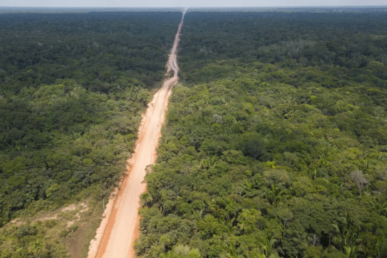
Just like the Belo Monte hydroelectric plant, projects such as BR-319 were conceived during the Brazilian Military Dictatorship. The highway was opened between 1968 and 1973, cutting through nearly 900 km of forest, all of which were once passable. However, by 1988, the road was abandoned and the forest had begun reclaiming it.
Successive governments have tried to reopen it, but these efforts have consistently faced resistance from Brazilian and international socio-environmental sector, fearing it would replicate the devastation and invasions seen along other Amazonian highways.
Despite past lessons, since 2015, under the Dilma Rousseff administration, segments of BR-319 have received asphalt “maintenance”, making it passable again — at least during the dry season. In the rainy season, much of it turns into a mud trap for those daring enough to cross it.
The license to pave 400 km and reconnect the entire highway, issued under the Bolsonaro administration, is the target of a public civil lawsuit. Meanwhile, smaller segments and bridges — such as those over the Curuçá and Autaz-Mirim rivers — have been authorized for “upgrades”, according to OBR-319.
That’s where much of the danger lies, say sources interviewed by ((o))eco. The full reconstruction of the highway would connect the well-preserved central portion of the Amazon to one of the national epicenters of deforestation: the “Amacro” region, which spans the states of Amazonas, Acre, and Rondônia.
“Much of this is encouraged by governments that, through inaction or direct policies, subsidize the transformation of forest into pasture, soy, and other crops”, said the scientist Philip Fearnside, of Inpa.
The outlook is even more concerning because land grabbing and deforestation from the so-called “Arc of Deforestation” could also be facilitated by other road projects, such as the federal BR-421 and the state AM-366, the latter cutting through the Nascentes do Jari National Park.
To make matters worse, there are also major oil and gas extraction projects planned for the same region influenced by BR-319.
Taken together, all of this could jeopardize roughly half of the remaining Brazilian Amazon rainforest, delivering severe blows to socio-environmental conservation, shrinking rainfall across the rest of the country, and pushing the global climate off balance.
“The vast area opened up by roads contains enough carbon to push global warming past a point of no return”, emphasized Fearnside, a PhD in Biological Sciences from the University of Michigan (USA).
This warning is echoed by researchers at the Federal University of Minas Gerais (UFMG, acronym in PT). They point out that by 2050, the restoration of BR-319 could lead to the deforestation of 170,000 square kilometres and the emission of 8 billion tons of CO₂ — rates four times higher than the regional historical average. These figures come from the ((o))eco special story “The Road of Discord in the Amazon.”
Amazonian vegetation and soil store vast amounts of carbon dioxide, which — when released through burning, deforestation, and forest degradation — amplifies the greenhouse effect and raises global average temperatures. These emissions are Brazil’s largest contribution to the climate crisis, according to the Climate Observatory (OC, acronym in PT), a platform dedicated to observing, analyzing, and reporting on climate change.


Winding path
For Marcelo Rodrigues, executive secretary of OBR-319, halting deforestation and forest degradation in the region depends on measures such as establishing agile and effective environmental enforcement and promoting economies that keep the forest standing, involving and benefiting local communities.
“The first step toward achieving more sustainable outcomes is to ensure effective governance in the territory even before carrying out infrastructure works — something that should be a given”, he added.
Philip Fearnside (Inpa), meanwhile, foresees more destruction if BR-319 is fully restored and did not hold back in his criticism of the governments, which he says are allowing social and environmental degradation along the highway. In his view, promises of deforestation control only serve to speed up the road’s paving.
“When you open up an area, there are thousands of independent actors making decisions. It’s not the governments in control”, said the scientist, who has lived and conducted research in the Amazon since 1978.
To him, pushing forward with projects like this shows that Brazil is on the “wrong path” and unfit to lead the world in confronting the climate crisis, as it hopes to do at Climate COP30 this November, in Amazon state of Pará. “You have to lead by example and act here first”, he said.
When asked about the legal and technical status of the environmental licensing for the central stretch of BR-319, the Ibama (acronym in PT to Brazilian Institute of Environment and Renewable Natural Resources), a federal agency under the Ministry of Environment, had not issued a statement by the time this report was finalized.
This story was originally published in Portuguese. The translation to English was done with the assistance of Artificial Intelligence, with final review by a human. For this story, the review was done by the reporter Aldem Bourscheit.
As informações apresentadas neste post foram reproduzidas do Site O Eco e são de total responsabilidade do autor.
Ver post do Autor